It would make things cleaner and easier if we could create circles and squares on the screen to group objects rather than relying on a background map that may or may not be of the proper dimensions to contain your articles.
simple lines and squares with formatting like dashed and dots would make my life so much simpler! meeting or beating paint functionality would be ideal. Not to mention the other atlas request to add a format painter, these tools would make atlas a functional tool for complex maps.
We all need this
Up for it. I am using a lot of labels and it would be great to draw a tiny dashed line between label and object to actually make it clear which object particular label belongs to
Good suggestion, I support
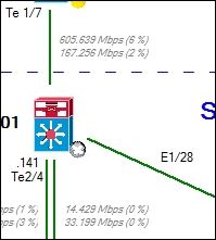
We do have separate send/receive stats on map in SolarWinds Network Atlas
To achieve this, simply add label to your interface and copy-paste the following:
Rx: ${Inbps} (${InPercentUtil})
Tx: ${Outbps} (${OutPercentUtil})
Note: In Network Atlas you will not see result straight away. Just save your map and open in the front-end
Hope helps,
Alex
Thanks Alex, I just removed my comment because of your solution ;-)
Regards,
Sef
I use Visio for the backgrounds but I'll vote up anyhow!
I just DL this to install the free trial. I think that would be great.
I would love for there to be an invisible or at least semitransparent map object, the shape of which is fully customizable. A free-hand drawing would accomplish the same purpose. With that we could divide a map into different sections by overlaying it with one of these objects so that a sub-map would be opened by simply clicking anywhere in the shaded area of the semitransparent object.
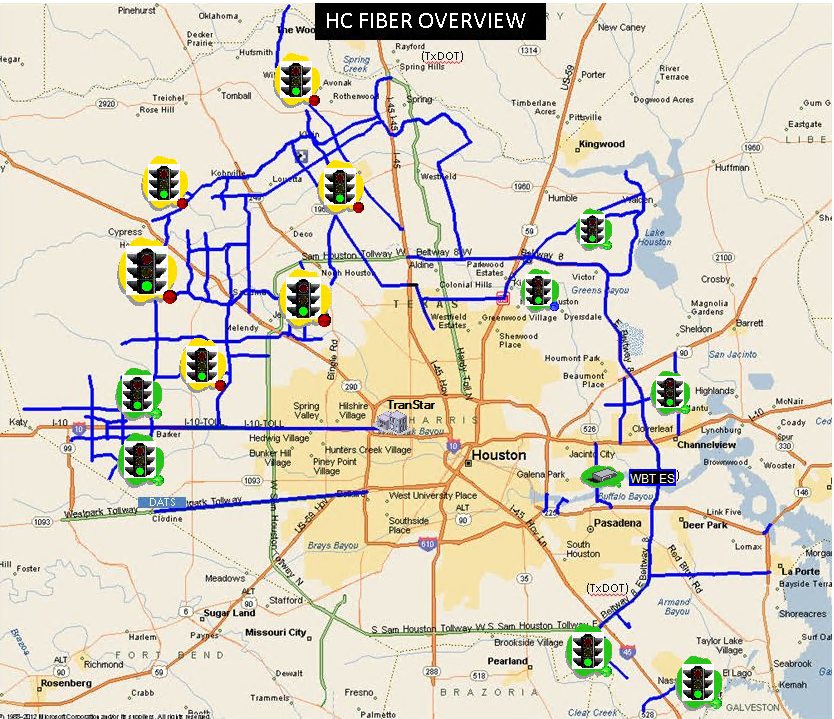
This is one of my maps and I would love to get rid of all of those "traffic light" objects (custom object I created) which are all embedded sub-maps and replace them with a semitransparent overlay that I can mold to fit exactly to the geographic area it represents. Right now, if you click on any of those objects it will go to another map that zooms in to that area on this map and show every node within that area along with their respective fiber paths.
I will try to create a representation of what this would look like if I had my way. If I'm able, I'll post that here later.
Would anyone else find this useful?